National Register of Historic Places listings in Union County, Pennsylvania

This is a list of the National Register of Historic Places listings in Union County, Pennsylvania.
This is intended to be a complete list of the properties and districts on the National Register of Historic Places in Union County, Pennsylvania, United States. The locations of National Register properties and districts for which the latitude and longitude coordinates are included below, may be seen in a map.[1]
There are 20 properties and districts listed on the National Register in the county.
This National Park Service list is complete through NPS recent listings posted June 7, 2024.[2]
Map all coordinates using OpenStreetMap
Download coordinates as:
- KML
- GPX (all coordinates)
- GPX (primary coordinates)
- GPX (secondary coordinates)
Current listings
| [3] | Name on the Register | Image | Date listed[4] | Location | City or town | Description |
|---|---|---|---|---|---|---|
| 1 | Allenwood River Bridge | 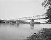 | June 22, 1988 (#88000865) | Legislative Route 460 over the West Branch of the Susquehanna River at Allenwood 41°06′28″N 76°53′25″W / 41.107778°N 76.890278°W / 41.107778; -76.890278 (Allenwood River Bridge) | Gregg Township | Bridge was replaced with a new structure in 1990. It extended into Delaware Township in Northumberland County |
| 2 | Buffalo Presbyterian Church |  | January 30, 1976 (#76001675) | West of Lewisburg on Pennsylvania Route 192 40°57′47″N 76°58′04″W / 40.963056°N 76.967778°W / 40.963056; -76.967778 (Buffalo Presbyterian Church) | Buffalo Township | |
| 3 | Chamberlin Iron Front Building | 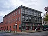 | May 14, 1979 (#79002347) | 434 Market Street 40°57′48″N 76°53′15″W / 40.963333°N 76.8875°W / 40.963333; -76.8875 (Chamberlin Iron Front Building) | Lewisburg | |
| 4 | Factory Bridge | 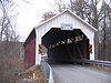 | February 8, 1980 (#80003645) | 1 mile (1.6 km) west of White Deer on Township 629 41°04′25″N 76°54′12″W / 41.073611°N 76.903333°W / 41.073611; -76.903333 (Factory Bridge) | White Deer Township | |
| 5 | Benjamin Griffey House |  | September 13, 1978 (#78002474) | West of Allenwood on Pennsylvania Route 44 41°07′18″N 76°57′56″W / 41.121667°N 76.965556°W / 41.121667; -76.965556 (Benjamin Griffey House) | Gregg Township | The house was badly damaged in a 1980 fire, and is no longer standing at its original location. |
| 6 | Halfway Lake Dam |  | May 11, 1987 (#87000046) | 16 miles (26 km) west of Lewisburg on Pennsylvania Route 192 40°59′24″N 77°11′23″W / 40.99°N 77.189722°W / 40.99; -77.189722 (Halfway Lake Dam) | Hartley Township | |
| 7 | Hassenplug Bridge |  | February 8, 1980 (#80003641) | North 4th Street 40°55′25″N 77°03′00″W / 40.923611°N 77.05°W / 40.923611; -77.05 (Hassenplug Bridge) | Mifflinburg | |
| 8 | Hayes Bridge | 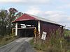 | February 8, 1980 (#80003642) | West of Mifflinburg on Township 376 40°55′34″N 77°05′32″W / 40.926111°N 77.092222°W / 40.926111; -77.092222 (Hayes Bridge) | West Buffalo Township | |
| 9 | William A. Heiss House and Buggy Shop |  | August 6, 1979 (#79002348) | 523 Green Street 40°54′53″N 77°02′55″W / 40.914722°N 77.048611°W / 40.914722; -77.048611 (William A. Heiss House and Buggy Shop) | Mifflinburg | |
| 10 | Lewisburg Armory |  | November 14, 1991 (#91001700) | U.S. Route 15 south of its junction with Pennsylvania Route 45 40°56′47″N 76°52′49″W / 40.946389°N 76.880278°W / 40.946389; -76.880278 (Lewisburg Armory) | East Buffalo Township | |
| 11 | Lewisburg Historic District | 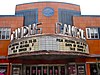 | July 28, 2004 (#04000759) | Roughly bounded by U.S. Route 15, Beck Street, the Susquehanna River, and the borough boundary 40°57′51″N 76°53′04″W / 40.964167°N 76.884444°W / 40.964167; -76.884444 (Lewisburg Historic District) | Lewisburg | |
| 12 | Mifflinburg Historic District |  | April 10, 1980 (#80003643) | Pennsylvania Route 45 40°54′59″N 77°02′58″W / 40.916389°N 77.049444°W / 40.916389; -77.049444 (Mifflinburg Historic District) | Mifflinburg | |
| 13 | Millmont Red Bridge |  | February 8, 1980 (#80003644) | Southwest of Millmont on Legislative Route 59005 40°52′41″N 77°09′21″W / 40.878056°N 77.155833°W / 40.878056; -77.155833 (Millmont Red Bridge) | Hartley Township | |
| 14 | New Berlin Presbyterian Church |  | October 26, 1972 (#72001178) | Vine and High Streets 40°52′46″N 76°59′13″W / 40.879444°N 76.986944°W / 40.879444; -76.986944 (New Berlin Presbyterian Church) | New Berlin | |
| 15 | Old Union County Courthouse |  | November 9, 1972 (#72001179) | Market and Vine Streets 40°52′43″N 76°59′12″W / 40.878611°N 76.986667°W / 40.878611; -76.986667 (Old Union County Courthouse) | New Berlin | |
| 16 | Packwood House-American Hotel |  | September 20, 1978 (#78002475) | 10 Market Street 40°57′59″N 76°52′57″W / 40.966389°N 76.8825°W / 40.966389; -76.8825 (Packwood House-American Hotel) | Lewisburg | |
| 17 | Reading Railroad Freight Station |  | January 22, 1992 (#91002012) | Junction of South 5th and St. Louis Streets 40°57′48″N 76°53′15″W / 40.963333°N 76.8875°W / 40.963333; -76.8875 (Reading Railroad Freight Station) | Lewisburg | |
| 18 | Slifer House |  | June 18, 1975 (#75001668) | North of Lewisburg off U.S. Route 15 on Pennsylvania Route 59024 40°58′33″N 76°52′59″W / 40.975833°N 76.883056°W / 40.975833; -76.883056 (Slifer House) | Kelly Township | |
| 19 | George Christian and Anna Catherine Spangler Farm |  | August 4, 2016 (#16000517) | 1175 Wildwood Rd. 40°51′52″N 77°01′48″W / 40.864526°N 77.030075°W / 40.864526; -77.030075 (George Christian and Anna Catherine Spangler Farm) | Mifflinburg | An 1802, two-story stone house and circa 1840 large bank barn are highlights of this historic farm. Located along Penns Creek the farm has been continuously farmed for well over 200 years. |
| 20 | Watsontown River Bridge |  | June 22, 1988 (#88000801) | Legislative Route 240 spur over the West Branch of the Susquehanna River 41°04′51″N 76°51′55″W / 41.080833°N 76.865278°W / 41.080833; -76.865278 (Watsontown River Bridge) | White Deer Township | Extends into Watsontown in Northumberland County |
See also
Wikimedia Commons has media related to National Register of Historic Places in Union County, Pennsylvania.
References
- ^ The latitude and longitude information provided in this table was derived originally from the National Register Information System, which has been found to be fairly accurate for about 99% of listings. Some locations in this table may have been corrected to current GPS standards.
- ^ National Park Service, United States Department of the Interior, "National Register of Historic Places: Weekly List Actions", retrieved June 7, 2024.
- ^ Numbers represent an alphabetical ordering by significant words. Various colorings, defined here, differentiate National Historic Landmarks and historic districts from other NRHP buildings, structures, sites or objects.
- ^ The eight-digit number below each date is the number assigned to each location in the National Register Information System database, which can be viewed by clicking the number.
- v
- t
- e

- Adams
- Allegheny
- Armstrong
- Beaver
- Bedford
- Berks
- Blair
- Bradford
- Bucks
- Butler
- Cambria
- Cameron
- Carbon
- Centre
- Chester
- Clarion
- Clearfield
- Clinton
- Columbia
- Crawford
- Cumberland
- Dauphin
- Delaware
- Elk
- Erie
- Fayette
- Forest
- Franklin
- Fulton
- Greene
- Huntingdon
- Indiana
- Jefferson
- Juniata
- Lackawanna
- Lancaster
- Lawrence
- Lebanon
- Lehigh
- Luzerne
- Lycoming
- McKean
- Mercer
- Mifflin
- Monroe
- Montgomery
- Montour
- Northampton
- Northumberland
- Perry
- Philadelphia
- Pike
- Potter
- Schuylkill
- Snyder
- Somerset
- Sullivan
- Susquehanna
- Tioga
- Union
- Venango
- Warren
- Washington
- Wayne
- Westmoreland
- Wyoming
- York
 Category
 NRHP portal


Municipalities and communities of Union County, Pennsylvania, United States | ||
|---|---|---|
County seat: Lewisburg | ||
| Boroughs |  | |
| Townships | ||
| CDPs | ||
| Unincorporated communities | ||
| ||


