National Register of Historic Places listings in Tioga County, Pennsylvania
This is a list of the National Register of Historic Places listings in Tioga County, Pennsylvania.
This is intended to be a complete list of the properties and districts on the National Register of Historic Places in Tioga County, Pennsylvania, United States. The locations of National Register properties and districts for which the latitude and longitude coordinates are included below, may be seen in a map.[1]
There are 10 properties and districts listed on the National Register in the county.
This National Park Service list is complete through NPS recent listings posted June 7, 2024.[2]
Map all coordinates using OpenStreetMap
Download coordinates as:
- KML
- GPX (all coordinates)
- GPX (primary coordinates)
- GPX (secondary coordinates)
Current listings
| [3] | Name on the Register | Image | Date listed[4] | Location | City or town | Description |
|---|---|---|---|---|---|---|
| 1 | Blackwell Methodist Episcopal Church |  | September 18, 2013 (#13000746) | 117 Blackwell Square 41°33′26″N 77°22′48″W / 41.557283°N 77.380117°W / 41.557283; -77.380117 (Blackwell Methodist Episcopal Church) | Morris Township | |
| 2 | Colton Point State Park | 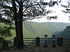 | February 12, 1987 (#87000112) | 5 miles (8.0 km) south of U.S. Route 6 at Ansonia 41°42′13″N 77°27′51″W / 41.703611°N 77.464167°W / 41.703611; -77.464167 (Colton Point State Park) | Shippen Township | |
| 3 | James Ford House |  | December 6, 1975 (#75001667) | Cowanesque Street 41°59′46″N 77°07′44″W / 41.996111°N 77.128889°W / 41.996111; -77.128889 (James Ford House) | Lawrenceville | |
| 4 | Mansfield Armory | 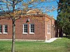 | May 9, 1991 (#91000515) | Smythe Park 41°48′23″N 77°04′46″W / 41.806389°N 77.079444°W / 41.806389; -77.079444 (Mansfield Armory) | Mansfield | |
| 5 | Parkhurst Memorial Presbyterian Church | 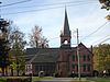 | April 16, 2012 (#12000224) | 302 W. Main St. 41°59′14″N 77°19′01″W / 41.98712°N 77.317082°W / 41.98712; -77.317082 (Parkhurst Memorial Presbyterian Church) | Elkland | |
| 6 | Robinson House |  | August 3, 1977 (#77001196) | 120 Main Street 41°44′48″N 77°18′14″W / 41.746667°N 77.303889°W / 41.746667; -77.303889 (Robinson House) | Wellsboro | |
| 7 | Jesse Robinson House | 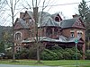 | February 21, 1991 (#91000089) | 141 Main Street 41°44′42″N 77°18′16″W / 41.745°N 77.304444°W / 41.745; -77.304444 (Jesse Robinson House) | Wellsboro | |
| 8 | Judge John Ryon House | 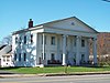 | December 16, 1977 (#77001195) | Main Street 41°59′41″N 77°07′35″W / 41.994722°N 77.126389°W / 41.994722; -77.126389 (Judge John Ryon House) | Lawrenceville | |
| 9 | Wellsboro Armory |  | May 9, 1991 (#91000521) | 2 Central Avenue 41°44′51″N 77°18′11″W / 41.7475°N 77.303056°W / 41.7475; -77.303056 (Wellsboro Armory) | Wellsboro | |
| 10 | Wellsboro Historic District | 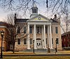 | January 5, 2005 (#04001458) | Roughly bounded by Nichols, Tioga, Charleston, Jackson Streets, East Avenue, Bacon Street, Morris Lane, Sturrock, Meade, Grant, Walnut, Academy Streets, West Avenue, West Water and Highland Streets 41°44′57″N 77°18′05″W / 41.749167°N 77.301389°W / 41.749167; -77.301389 (Wellsboro Historic District) | Wellsboro |
See also
References
Wikimedia Commons has media related to National Register of Historic Places in Tioga County, Pennsylvania.
- ^ The latitude and longitude information provided in this table was derived originally from the National Register Information System, which has been found to be fairly accurate for about 99% of listings. Some locations in this table may have been corrected to current GPS standards.
- ^ National Park Service, United States Department of the Interior, "National Register of Historic Places: Weekly List Actions", retrieved June 7, 2024.
- ^ Numbers represent an alphabetical ordering by significant words. Various colorings, defined here, differentiate National Historic Landmarks and historic districts from other NRHP buildings, structures, sites or objects.
- ^ The eight-digit number below each date is the number assigned to each location in the National Register Information System database, which can be viewed by clicking the number.
- v
- t
- e

- Adams
- Allegheny
- Armstrong
- Beaver
- Bedford
- Berks
- Blair
- Bradford
- Bucks
- Butler
- Cambria
- Cameron
- Carbon
- Centre
- Chester
- Clarion
- Clearfield
- Clinton
- Columbia
- Crawford
- Cumberland
- Dauphin
- Delaware
- Elk
- Erie
- Fayette
- Forest
- Franklin
- Fulton
- Greene
- Huntingdon
- Indiana
- Jefferson
- Juniata
- Lackawanna
- Lancaster
- Lawrence
- Lebanon
- Lehigh
- Luzerne
- Lycoming
- McKean
- Mercer
- Mifflin
- Monroe
- Montgomery
- Montour
- Northampton
- Northumberland
- Perry
- Philadelphia
- Pike
- Potter
- Schuylkill
- Snyder
- Somerset
- Sullivan
- Susquehanna
- Tioga
- Union
- Venango
- Warren
- Washington
- Wayne
- Westmoreland
- Wyoming
- York
 Category
 NRHP portal


Municipalities and communities of Tioga County, Pennsylvania, United States | ||
|---|---|---|
County seat: Wellsboro | ||
| Boroughs |  | |
| Townships | ||
| CDPs | ||
| Unincorporated communities | ||
| ||


