National Register of Historic Places listings in King County, Washington

This is a list of the National Register of Historic Places listings in King County, Washington.
This is intended to be a complete list of the properties and districts on the National Register of Historic Places in King County, Washington, United States. Latitude and longitude coordinates are provided for many National Register properties and districts; these locations may be seen together in an online map.[1]
There are 313 properties and districts listed on the National Register in the county. 220 of these listings are located in the city of Seattle, and are listed separately; the remaining 93 properties and districts are listed here. Another property in the county outside of Seattle was once listed on the National Register but has been removed.
This National Park Service list is complete through NPS recent listings posted June 14, 2024.[2]
Map all coordinates using OpenStreetMap
Download coordinates as:
- KML
- GPX (all coordinates)
- GPX (primary coordinates)
- GPX (secondary coordinates)
Current listings
| [3] | Name on the Register[4] | Image | Date listed[5] | Location | City or town | Description |
|---|---|---|---|---|---|---|
| 1 | William and Estella Adair Farm | 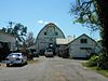 | March 22, 2002 (#02000249) | 27929 NE 100th St. 47°41′01″N 121°57′56″W / 47.683611°N 121.965556°W / 47.683611; -121.965556 (William and Estella Adair Farm) | Carnation | |
| 2 | Horatio and Laura Allen Farm | 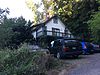 | March 22, 2002 (#02000250) | 28704 NE Cherry Valley Rd. 47°45′06″N 121°57′04″W / 47.751667°N 121.951111°W / 47.751667; -121.951111 (Horatio and Laura Allen Farm) | Duvall | |
| 3 | Arthur Foss | 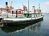 | April 11, 1989 (#89001078) | Moss Bay waterfront 47°40′30″N 122°12′26″W / 47.675°N 122.207222°W / 47.675; -122.207222 (Arthur Foss) | Kirkland | The Arthur Foss, although registered in Kirkland, is now based at Northwest Seaport in Seattle. |
| 4 | Auburn Post Office |  | April 21, 2000 (#00000407) | 20 Auburn Ave. NE 47°18′29″N 122°13′35″W / 47.308056°N 122.226389°W / 47.308056; -122.226389 (Auburn Post Office) | Auburn | |
| 5 | Auburn Public Library |  | August 3, 1982 (#82004221) | 306 Auburn Ave. 47°18′34″N 122°13′38″W / 47.309444°N 122.227222°W / 47.309444; -122.227222 (Auburn Public Library) | Auburn | Carnegie Libraries of Washington TR |
| 6 | Baring Bridge |  | August 26, 2019 (#100004331) | NE Index Creek Road off US 2 over S. Fork of Skykomish River 47°45′55″N 121°28′50″W / 47.7653°N 121.4806°W / 47.7653; -121.4806 (Baring Bridge) | Baring | |
| 7 | Black Diamond Cemetery |  | April 21, 2000 (#00000406) | Cemetery Hill Rd. 47°18′39″N 122°00′55″W / 47.310833°N 122.015278°W / 47.310833; -122.015278 (Black Diamond Cemetery) | Black Diamond | |
| 8 | Oscar Blomeen House |  | June 21, 1991 (#91000781) | 324 B St. NE. 47°18′40″N 122°13′35″W / 47.311111°N 122.226389°W / 47.311111; -122.226389 (Oscar Blomeen House) | Auburn | |
| 9 | William E. Boeing House |  | December 16, 1988 (#88002743) | Huckleberry Ln. 47°44′50″N 122°22′18″W / 47.747222°N 122.371667°W / 47.747222; -122.371667 (William E. Boeing House) | Highlands | Gated, guarded community; photo here http://www.nps.gov/nr/travel/aviation/boe.htm |
| 10 | Bothell Pioneer Cemetery |  | February 16, 1996 (#96000050) | Jct. of 108th Ave. NE. and NE. 180th St., NE and SE corners 47°45′32″N 122°11′39″W / 47.758889°N 122.194167°W / 47.758889; -122.194167 (Bothell Pioneer Cemetery) | Bothell | Bothell MPS |
| 11 | Brandes House | Upload image | December 14, 1994 (#94001436) | 2202 212th Ave. SE. 47°34′39″N 122°03′14″W / 47.5775°N 122.053889°W / 47.5775; -122.053889 (Brandes House) | Sammamish | |
| 12 | Camp North Bend |  | April 29, 1993 (#93000372) | 45509 SE. 150th St. 47°28′10″N 121°43′58″W / 47.469444°N 121.732778°W / 47.469444; -121.732778 (Camp North Bend) | North Bend vicinity | |
| 13 | Dr. Reuben Chase House | 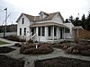 | August 27, 1990 (#90001246) | 17819 113th Ave. NE 47°45′27″N 122°11′20″W / 47.7575°N 122.188889°W / 47.7575; -122.188889 (Dr. Reuben Chase House) | Bothell | Bothell MPS |
| 14 | James W. Clise House |  | June 19, 1973 (#73001874) | 6046 Lake Sammamish Pkwy., NE 47°39′42″N 122°07′13″W / 47.661667°N 122.120278°W / 47.661667; -122.120278 (James W. Clise House) | Redmond | |
| 15 | Colvos Store | 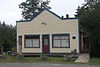 | August 10, 2000 (#00000970) | 123rd Ave. SW and Cove Rd. 47°27′55″N 122°29′29″W / 47.465278°N 122.491389°W / 47.465278; -122.491389 (Colvos Store) | Vashon | |
| 16 | Covenant Beach Bible Camp | 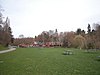 | January 11, 2006 (#05000313) | Cliff Ave. and 220th St. 47°24′26″N 122°19′43″W / 47.407222°N 122.328611°W / 47.407222; -122.328611 (Covenant Beach Bible Camp) | Des Moines | |
| 17 | Covington Electrical Substation, Bonneville Power Administration |  | May 29, 2018 (#100002475) | 28401 Covington Way SE 47°20′58″N 122°07′10″W / 47.3495°N 122.1195°W / 47.3495; -122.1195 (Covington Electrical Substation, Bonneville Power Administration) | Covington | |
| 18 | Dockton Hotel | Upload image | July 28, 1983 (#83003337) | 260th St., SE and 99th Ave., SW 47°22′15″N 122°27′38″W / 47.370833°N 122.460556°W / 47.370833; -122.460556 (Dockton Hotel) | Dockton | Better known as "Dockton School". Presumed demolished. |
| 19 | John and Kate Dougherty Farmstead |  | December 1, 2005 (#05001353) | 26524 NE Cherry Valley Rd. 47°45′05″N 121°59′03″W / 47.751389°N 121.984167°W / 47.751389; -121.984167 (John and Kate Dougherty Farmstead) | Duvall | |
| 20 | Dr. Trueblood House |  | August 3, 1982 (#82004222) | 129 6th Ave. 47°40′46″N 122°12′25″W / 47.67943°N 122.20697°W / 47.67943; -122.20697 (Dr. Trueblood House) | Kirkland | |
| 21 | James G. Eddy House and Grounds | 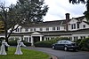 | February 19, 1982 (#82004226) | 1005 Evergreen Point Rd. 47°37′11″N 122°14′23″W / 47.619722°N 122.239722°W / 47.619722; -122.239722 (James G. Eddy House and Grounds) | Medina | |
| 22 | David and Martha Entwistles House | 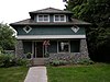 | July 28, 1999 (#99000918) | 32021 E. Entwistle St. 47°38′52″N 121°54′31″W / 47.647778°N 121.908611°W / 47.647778; -121.908611 (David and Martha Entwistles House) | Carnation | |
| 23 | Falls City Masonic Hall |  | August 25, 2004 (#04000922) | 4304 337th Place SE 47°34′01″N 121°53′21″W / 47.566944°N 121.889167°W / 47.566944; -121.889167 (Falls City Masonic Hall) | Fall City | |
| 24 | Faust-Ryan House | 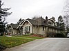 | May 19, 1994 (#94000405) | 18604 104th Ave. 47°45′49″N 122°11′56″W / 47.763611°N 122.198889°W / 47.763611; -122.198889 (Faust-Ryan House) | Bothell | Bothell MPS |
| 25 | Gaffney's Lake Wilderness Lodge |  | March 28, 2003 (#03000163) | 22500 SE 248th St. 47°22′45″N 122°02′14″W / 47.379167°N 122.037222°W / 47.379167; -122.037222 (Gaffney's Lake Wilderness Lodge) | Maple Valley | |
| 26 | Great Northern Depot | 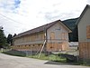 | April 14, 1997 (#97000322) | Jct. of Railroad Ave. and 4th St., SE corner 47°42′34″N 121°21′34″W / 47.709444°N 121.359444°W / 47.709444; -121.359444 (Great Northern Depot) | Skykomish | |
| 27 | Andrew and Bergette Hjertoos Farm |  | March 22, 2002 (#02000248) | 31523 NE 40th 47°38′34″N 121°54′59″W / 47.642778°N 121.916389°W / 47.642778; -121.916389 (Andrew and Bergette Hjertoos Farm) | Carnation | |
| 28 | Hollywood Farm | 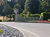 | December 15, 1978 (#78002757) | SE of Woodinville at 14111 NE 145th St. 47°43′48″N 122°08′59″W / 47.73°N 122.149722°W / 47.73; -122.149722 (Hollywood Farm) | Woodinville | |
| 29 | Independent Order of Odd Fellows (IOOF) Hall No. 148 |  | July 28, 1999 (#99000917) | 3940 Tolt Ave. 47°38′39″N 121°54′51″W / 47.644167°N 121.914167°W / 47.644167; -121.914167 (Independent Order of Odd Fellows (IOOF) Hall No. 148) | Carnation | |
| 30 | Issaquah Depot | 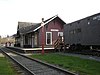 | September 13, 1990 (#90001461) | Rainier Ave. N 47°31′53″N 122°02′02″W / 47.531389°N 122.033889°W / 47.531389; -122.033889 (Issaquah Depot) | Issaquah | |
| 31 | Issaquah Sportsmen's Club | 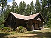 | November 19, 1998 (#98001419) | 23600 SE Evans St. 47°31′36″N 122°01′31″W / 47.526667°N 122.025278°W / 47.526667; -122.025278 (Issaquah Sportsmen's Club) | Issaquah | |
| 32 | Jovita Land Company Model Home-Corbett House | 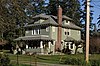 | March 10, 2004 (#04000158) | 4600 S. 364th St. 47°16′33″N 122°16′32″W / 47.275833°N 122.275556°W / 47.275833; -122.275556 (Jovita Land Company Model Home-Corbett House) | Federal Way | |
| 33 | Keewaydin Clubhouse |  | August 24, 2005 (#05000923) | 1836 72nd Ave. SE 47°35′44″N 122°14′34″W / 47.595556°N 122.242778°W / 47.595556; -122.242778 (Keewaydin Clubhouse) | Mercer Island | |
| 34 | Lilly Kirk House |  | March 9, 1995 (#95000188) | 19619 100th Ave. NE 47°46′15″N 122°12′28″W / 47.770833°N 122.207778°W / 47.770833; -122.207778 (Lilly Kirk House) | Bothell | Bothell MPS |
| 35 | Peter Kirk Building |  | August 14, 1973 (#73001873) | 620 Market St. 47°40′49″N 122°12′34″W / 47.68022°N 122.20939°W / 47.68022; -122.20939 (Peter Kirk Building) | Kirkland | |
| 36 | Kirkland Woman's Club | 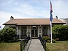 | January 26, 1990 (#89002321) | 407 First St. 47°40′42″N 122°12′31″W / 47.67837°N 122.20863°W / 47.67837; -122.20863 (Kirkland Woman's Club) | Kirkland | |
| 37 | Lakeview School |  | June 16, 1988 (#88000742) | Island Crest Way and S.E. Sixty-eighth St. 47°32′31″N 122°13′14″W / 47.541944°N 122.220556°W / 47.541944; -122.220556 (Lakeview School) | Mercer Island | Rural Public Schools of Washington State MPS |
| 38 | Lester Depot |  | September 10, 1987 (#87001534) | US Forest Service Rd. 212, Green River Watershed 47°12′32″N 121°29′38″W / 47.208889°N 121.493889°W / 47.208889; -121.493889 (Lester Depot) | Lester | Has been demolished. |
| 39 | Loomis House |  | August 3, 1982 (#82004223) | 304 8th Ave., W. 47°40′58″N 122°12′41″W / 47.6829°N 122.21128°W / 47.6829; -122.21128 (Loomis House) | Kirkland | |
| 40 | Maloney's General Store | 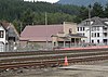 | August 29, 1997 (#97001078) | 104 Railroad Ave. W 47°42′34″N 121°21′40″W / 47.709444°N 121.361111°W / 47.709444; -121.361111 (Maloney's General Store) | Skykomish | |
| 41 | Louis S. Marsh House |  | June 30, 1989 (#89000500) | 6604 Lake Washington Blvd. 47°39′57″N 122°12′16″W / 47.665833°N 122.204444°W / 47.665833; -122.204444 (Louis S. Marsh House) | Kirkland | |
| 42 | Marymoor Prehistoric Indian Site |  | November 20, 1970 (#70000642) | Address Restricted | Redmond | |
| 43 | Masonic Lodge Building |  | August 3, 1982 (#82004224) | 700 Market St. 47°40′50″N 122°12′34″W / 47.68053°N 122.20932°W / 47.68053; -122.20932 (Masonic Lodge Building) | Kirkland | |
| 44 | Masonic Temple-Auburn |  | July 21, 2015 (#15000454) | 10 Auburn Way S. 47°18′27″N 122°13′32″W / 47.3074°N 122.2255°W / 47.3074; -122.2255 (Masonic Temple-Auburn) | Auburn | |
| 45 | McGrath Cafe and Hotel (The McGrath) |  | February 21, 2002 (#02000089) | 101 W. North Bend Way 47°29′42″N 121°47′05″W / 47.495°N 121.784722°W / 47.495; -121.784722 (McGrath Cafe and Hotel (The McGrath)) | North Bend | |
| 46 | Messenger of Peace Chapel Car |  | January 21, 2009 (#08000998) | 38625 SE King St. 47°31′42″N 121°49′38″W / 47.528267°N 121.827136°W / 47.528267; -121.827136 (Messenger of Peace Chapel Car) | Snoqualmie | |
| 47 | Mukai Cold Process Fruit Barrelling Plant | 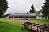 | September 26, 1994 (#94001165) | 18005, 18017 107th Ave. SW 47°26′36″N 122°28′16″W / 47.443333°N 122.471111°W / 47.443333; -122.471111 (Mukai Cold Process Fruit Barrelling Plant) | Vashon | |
| 48 | Aaron Neely Sr., Mansion |  | October 15, 1974 (#74001955) | E of Auburn off WA 18 47°18′03″N 122°10′36″W / 47.300833°N 122.176667°W / 47.300833; -122.176667 (Aaron Neely Sr., Mansion) | Auburn | |
| 49 | Neighbor-Bennett House |  | August 25, 2004 (#04000921) | 4317-337th Place SE 47°31′27″N 121°53′27″W / 47.524167°N 121.890833°W / 47.524167; -121.890833 (Neighbor-Bennett House) | Fall City | |
| 50 | Nelson–Parker House | 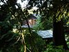 | April 21, 2014 (#14000166) | 17605 182nd Ave, NE 47°45′21″N 122°05′51″W / 47.755893°N 122.097437°W / 47.755893; -122.097437 (Nelson–Parker House) | Woodinville | |
| 51 | Norman Bridge |  | July 19, 1994 (#94000676) | Old 428th Ave. SE, across the N. Fork, Snoqualmie R. 47°30′58″N 121°46′05″W / 47.516111°N 121.768056°W / 47.516111; -121.768056 (Norman Bridge) | North Bend | Has been demolished. |
| 52 | North Bend Ranger Station |  | March 6, 1991 (#91000157) | 42404 SE. North Bend Way 47°29′23″N 121°46′20″W / 47.489722°N 121.772222°W / 47.489722; -121.772222 (North Bend Ranger Station) | North Bend | |
| 53 | Louis and Ellen Olson House | 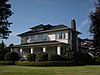 | August 30, 1984 (#84003492) | 1513 Griffin Ave. 47°12′20″N 121°59′30″W / 47.205556°N 121.991667°W / 47.205556; -121.991667 (Louis and Ellen Olson House) | Enumclaw | |
| 54 | Mary Olson Farm |  | October 5, 2001 (#01001080) | 28728 Green River Rd. S. 47°20′40″N 122°12′13″W / 47.344444°N 122.203611°W / 47.344444; -122.203611 (Mary Olson Farm) | Kent | |
| 55 | Pacific Coast Company House No. 75 |  | December 21, 1979 (#79002534) | N of Renton at 7210 138th St., SE 47°32′17″N 122°09′21″W / 47.538056°N 122.155833°W / 47.538056; -122.155833 (Pacific Coast Company House No. 75) | Renton | |
| 56 | Luigi and Aurora Pagani House |  | August 9, 2002 (#02000861) | 32907 Merino St. 47°18′24″N 122°00′23″W / 47.306667°N 122.006389°W / 47.306667; -122.006389 (Luigi and Aurora Pagani House) | Black Diamond | |
| 57 | Patton Bridge |  | May 24, 1995 (#95000626) | Green Valley Rd. over the Green R. 47°17′18″N 122°09′34″W / 47.288333°N 122.159444°W / 47.288333; -122.159444 (Patton Bridge) | Auburn | Bridges of Washington State MPS |
| 58 | Pickering Farm |  | July 7, 1983 (#83003343) | 21809 SE 56th St. 47°32′58″N 122°02′55″W / 47.549444°N 122.048611°W / 47.549444; -122.048611 (Pickering Farm) | Issaquah | |
| 59 | Point Robinson Light Station |  | April 21, 2004 (#04000359) | NE end of Maury Island in Puget Sound 47°23′16″N 122°22′29″W / 47.387778°N 122.374722°W / 47.387778; -122.374722 (Point Robinson Light Station) | Vashon Island | |
| 60 | Preston Community Clubhouse | 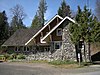 | December 4, 2008 (#08001186) | 8625 310th Ave. SE 47°31′34″N 121°56′11″W / 47.526011°N 121.936414°W / 47.526011; -121.936414 (Preston Community Clubhouse) | Preston | |
| 61 | Redmond City Park | 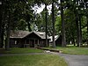 | January 6, 2009 (#08001302) | 7802 168th Ave NE 47°40′23″N 122°06′56″W / 47.672989°N 122.115572°W / 47.672989; -122.115572 (Redmond City Park) | Redmond | |
| 62 | RELIEF (lightship) |  | April 23, 1975 (#75001852) | Central Waterfront at Moss Bay 47°40′30″N 122°12′26″W / 47.675°N 122.207222°W / 47.675; -122.207222 (RELIEF (lightship)) | Kirkland | |
| 63 | St. Edward Seminary |  | March 8, 2007 (#07000137) | 14445 Juanita Dr. NE 47°43′58″N 122°14′45″W / 47.732722°N 122.245911°W / 47.732722; -122.245911 (St. Edward Seminary) | Kenmore | |
| 64 | Erick Gustave Sanders Mansion | 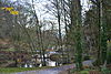 | November 6, 1986 (#86003163) | 5516 S. Two Hundred and Seventy-seventh St. 47°21′17″N 122°15′50″W / 47.354722°N 122.263889°W / 47.354722; -122.263889 (Erick Gustave Sanders Mansion) | Kent | |
| 65 | Joshua Sears Building |  | August 3, 1982 (#82004225) | 701 Market St. 47°40′51″N 122°12′35″W / 47.68074°N 122.20981°W / 47.68074; -122.20981 (Joshua Sears Building) | Kirkland | |
| 66 | Seattle Municipal Light and Power Plant | 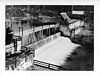 | September 11, 1997 (#97001077) | 20030 Cedar Falls Rd. SE 47°25′04″N 121°46′05″W / 47.417778°N 121.768056°W / 47.417778; -121.768056 (Seattle Municipal Light and Power Plant) | North Bend vicinity | Also known as Cedar Falls Historic District |
| 67 | Seattle Naval Hospital Chapel |  | December 26, 2023 (#100009645) | 1902 NE 150th Street 47°44′15″N 122°18′27″W / 47.7375°N 122.3074°W / 47.7375; -122.3074 (Seattle Naval Hospital Chapel) | Shoreline | |
| 68 | Selleck Historic District |  | March 16, 1989 (#89000214) | SE 252nd 47°22′33″N 121°52′00″W / 47.375833°N 121.866667°W / 47.375833; -121.866667 (Selleck Historic District) | Selleck | |
| 69 | Shawnee House |  | November 22, 2000 (#00001449) | 11608 SW Shawnee Rd. 47°22′56″N 122°28′57″W / 47.382222°N 122.4825°W / 47.382222; -122.4825 (Shawnee House) | Vashon | |
| 70 | Si View Park |  | January 7, 2015 (#14001143) | 400 SE. Orchard Dr. 47°29′27″N 121°46′58″W / 47.4907°N 121.7828°W / 47.4907; -121.7828 (Si View Park) | North Bend | |
| 71 | Skykomish Historic Commercial District |  | August 10, 2000 (#00000974) | Railroad Ave., from 3rd St. to W of N 6th St., and part of Old Cascade Hwy. 47°42′35″N 121°21′34″W / 47.709722°N 121.359444°W / 47.709722; -121.359444 (Skykomish Historic Commercial District) | Skykomish | |
| 72 | Snoqualmie Depot |  | July 24, 1974 (#74001963) | 109 King St. 47°31′43″N 121°49′28″W / 47.528611°N 121.824444°W / 47.528611; -121.824444 (Snoqualmie Depot) | Snoqualmie | |
| 73 | Snoqualmie Falls | 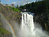 | September 2, 2009 (#92000784) | Snoqualmie R. below crossing of WA 522 47°32′29″N 121°50′14″W / 47.541464°N 121.837344°W / 47.541464; -121.837344 (Snoqualmie Falls) | Snoqualmie | |
| 74 | Snoqualmie Falls Cavity Generating Station |  | April 23, 1976 (#76001895) | N of Snoqualmie on Snoqualmie River 47°32′27″N 121°50′15″W / 47.540920°N 121.837381°W / 47.540920; -121.837381 (Snoqualmie Falls Cavity Generating Station) | Snoqualmie | |
| 75 | Snoqualmie Falls Hydroelectric Power Plant Historic District | 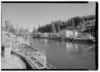 | October 24, 1992 (#92001324) | WA 202, .5 mi. N of Snoqualmie 47°32′26″N 121°50′13″W / 47.540672°N 121.836947°W / 47.540672; -121.836947 (Snoqualmie Falls Hydroelectric Power Plant Historic District) | Snoqualmie | |
| 76 | Snoqualmie School Campus |  | March 16, 1989 (#89000209) | Silva and King Sts. 47°31′44″N 121°49′38″W / 47.528889°N 121.827222°W / 47.528889; -121.827222 (Snoqualmie School Campus) | Snoqualmie | |
| 77 | Sorenson House | 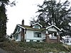 | March 9, 1995 (#95000187) | 10011 W. Riverside Dr. 47°45′23″N 122°12′19″W / 47.756389°N 122.205278°W / 47.756389; -122.205278 (Sorenson House) | Bothell | Bothell MPS |
| 78 | Helmer and Selma Steen House |  | August 10, 2000 (#00000976) | 10924 SW Cove Rd. 47°27′22″N 122°28′24″W / 47.456111°N 122.473333°W / 47.456111; -122.473333 (Helmer and Selma Steen House) | Vashon | |
| 79 | Stevens Pass Historic District |  | October 22, 1976 (#76001884) | West of Berne on U.S. 2 47°44′40″N 121°06′03″W / 47.744444°N 121.100833°W / 47.744444; -121.100833 (Stevens Pass Historic District) | Berne | |
| 80 | William Harper Thorton House | 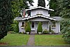 | November 7, 1997 (#97001408) | 17424 95th Ave, NE 47°45′19″N 122°12′44″W / 47.755278°N 122.212222°W / 47.755278; -122.212222 (William Harper Thorton House) | Bothell | Bothell MPS |
| 81 | TOURIST II (auto ferry) | 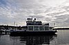 | April 15, 1997 (#97000321) | 25 Lake Shore Plaze, Marina Park 47°40′29″N 122°12′27″W / 47.674722°N 122.2075°W / 47.674722; -122.2075 (TOURIST II (auto ferry)) | Kirkland | |
| 82 | Tracy House | 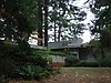 | July 13, 1995 (#95000830) | 18971 Edgecliff Dr. SW. 47°25′57″N 122°20′58″W / 47.4325°N 122.349444°W / 47.4325; -122.349444 (Tracy House) | Normandy Park | The NRHP lists this in Seattle, but it is actually in Normandy Park.[6] |
| 83 | Trommald Building | 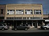 | August 24, 2000 (#00000972) | 1523-1525 Cole St. 47°12′12″N 121°59′19″W / 47.203333°N 121.988611°W / 47.203333; -121.988611 (Trommald Building) | Enumclaw | |
| 84 | Tukwila School |  | November 29, 1979 (#79002544) | 14475 59th Ave., S. 47°28′20″N 122°15′25″W / 47.472222°N 122.256944°W / 47.472222; -122.256944 (Tukwila School) | Tukwila | Now Tukwila Heritage and Cultural Center. |
| 85 | Untitled Earthwork-Johnson Pit #30 | 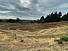 | August 16, 2021 (#100006801) | 21610 37th Place South 47°24′27″N 122°17′01″W / 47.4075°N 122.2836°W / 47.4075; -122.2836 (Untitled Earthwork-Johnson Pit #30) | SeaTac | |
| 86 | Vashon Hardware Store | 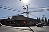 | August 10, 2000 (#00000971) | 17601 99th Ave. SW 47°26′50″N 122°27′34″W / 47.447222°N 122.459444°W / 47.447222; -122.459444 (Vashon Hardware Store) | Vashon | |
| 87 | Vincent School |  | August 25, 2004 (#04000920) | 8010 W. Snoqualmie Valley Rd. 47°40′26″N 121°58′42″W / 47.673889°N 121.978333°W / 47.673889; -121.978333 (Vincent School) | Carnation | Rural Public Schools of Washington State MPS |
| 88 | Dr. Johan and Louise Wenberg House |  | May 20, 2024 (#100010385) | 5360 232nd Avenue SE 47°33′11″N 122°01′49″W / 47.5531°N 122.0303°W / 47.5531; -122.0303 (Dr. Johan and Louise Wenberg House) | Issaquah | |
| 89 | Frederick W. Winters House |  | April 21, 1992 (#92000367) | 2102 Bellevue Way, SE. 47°35′30″N 122°11′31″W / 47.591667°N 122.191944°W / 47.591667; -122.191944 (Frederick W. Winters House) | Bellevue | |
| 90 | Woodinville School |  | August 28, 2017 (#100001517) | 13203 NE. 175th St 47°45′15″N 122°09′46″W / 47.754195°N 122.162799°W / 47.754195; -122.162799 (Woodinville School) | Woodinville | |
| 91 | F. W. Woolworth Company Store |  | December 8, 2015 (#15000880) | 724 S. 3rd St. 47°28′48″N 122°12′25″W / 47.479876°N 122.207014°W / 47.479876; -122.207014 (F. W. Woolworth Company Store) | Renton | |
| 92 | Harry Vanderbilt Wurdemann House |  | December 27, 1990 (#90002154) | 17602 Bothell Way NE 47°45′19″N 122°16′29″W / 47.755278°N 122.274722°W / 47.755278; -122.274722 (Harry Vanderbilt Wurdemann House) | Lake Forest Park | |
| 93 | The Yellowstone Road |  | December 2, 1974 (#74001956) | 196th St. between the Fall City Hwy. and 80th, NE 47°39′59″N 122°06′03″W / 47.666389°N 122.100833°W / 47.666389; -122.100833 (The Yellowstone Road) | Redmond |
Former listings
| [3] | Name on the Register | Image | Date listed | Date removed | Location | City or town | Description |
|---|---|---|---|---|---|---|---|
| 1 | Enumclaw High School |  | August 30, 1984 (#84003488) | January 20, 1988 | 2222 Porter St. | Enumclaw | Demolished |
See also
- List of Landmarks in Seattle (city landmarks)
- National Register of Historic Places listings in Seattle, Washington
- List of landmarks in King County, Washington (county landmarks)
- List of National Historic Landmarks in Washington (state)
References
- ^ The latitude and longitude information provided in this table was derived originally from the National Register Information System, which has been found to be fairly accurate for about 99% of listings. Some locations in this table may have been corrected to current GPS standards.
- ^ National Park Service, United States Department of the Interior, "National Register of Historic Places: Weekly List Actions", retrieved June 14, 2024.
- ^ a b Numbers represent an alphabetical ordering by significant words. Various colorings, defined here, differentiate National Historic Landmarks and historic districts from other NRHP buildings, structures, sites or objects.
- ^ "National Register Information System". National Register of Historic Places. National Park Service. April 24, 2008.
- ^ The eight-digit number below each date is the number assigned to each location in the National Register Information System database, which can be viewed by clicking the number.
- ^ Donald Langmead, Frank Lloyd Wright: A Bio-Bibliography, Praeger/Greenwood (2003), ISBN 0-313-31993-6. p. 34.
External links
Wikimedia Commons has media related to National Register of Historic Places in King County, Washington.
- WASHINGTON - King County at nationalregisterofhistoricplaces.com
- WASHINGTON - King County - Historic Districts at nationalregisterofhistoricplaces.com
- v
- t
- e
- List of U.S. National Historic Landmarks by state:
- Alabama
- Alaska
- Arizona
- Arkansas
- California
- Colorado
- Connecticut
- Delaware
- Florida
- Georgia
- Hawaii
- Idaho
- Illinois
- Indiana
- Iowa
- Kansas
- Kentucky
- Louisiana
- Maine
- Maryland
- Massachusetts
- Michigan
- Minnesota
- Mississippi
- Missouri
- Montana
- Nebraska
- Nevada
- New Hampshire
- New Jersey
- New Mexico
- New York
- North Carolina
- North Dakota
- Ohio
- Oklahoma
- Oregon
- Pennsylvania
- Rhode Island
- South Carolina
- South Dakota
- Tennessee
- Texas
- Utah
- Vermont
- Virginia
- Washington
- West Virginia
- Wisconsin
- Wyoming
 National Register of Historic Places portal
 Category


National Register of Historic Places listings in Washington (state) | ||
|---|---|---|
| Lists by county |
|  |
| Other lists |
| |


