Bech
Commune in Echternach, Luxembourg
Bech Bech | |
|---|---|
 | |
 Coat of arms | |
 Map of Luxembourg with Bech highlighted in orange, and the canton in dark red | |
| Coordinates: 49°45′10″N 6°21′40″E / 49.7528°N 6.3611°E / 49.7528; 6.3611 | |
| Country |  Luxembourg Luxembourg |
| Canton | Echternach |
| Government | |
| • Mayor | Jill Goeres |
| Area | |
| • Total | 23.31 km2 (9.00 sq mi) |
| • Rank | 39th of 100 |
| Highest elevation | 408 m (1,339 ft) |
| • Rank | 43rd of 100 |
| Lowest elevation | 261 m (856 ft) |
| • Rank | 64th of 100 |
| Population (2023) | |
| • Total | 1,357 |
| • Rank | 93rd of 100 |
| • Density | 58/km2 (150/sq mi) |
| • Rank | 87th of 100 |
| Time zone | UTC+1 (CET) |
| • Summer (DST) | UTC+2 (CEST) |
| LAU 2 | LU0001002 |
| Website | bech.lu |
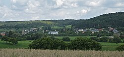
Bech is a commune and small town in eastern Luxembourg. It is part of the canton of Echternach, which until 2015 was part of the district of Grevenmacher.
As of 2024[update], the town of Bech, which lies in the east of the commune, has a population of 459.[1] Villages within the commune include Altrier and Rippig.

Population
Graphs are unavailable due to technical issues. There is more info on Phabricator and on MediaWiki.org. |
References
External links
 Media related to Bech at Wikimedia Commons
Places adjacent to Bech | |
|---|---|


- v
- t
- e
Authority control databases | |
|---|---|
| International |
|
| National |
|
 | This article related to the geography of Echternach canton is a stub. You can help Wikipedia by expanding it. |
- v
- t
- e


